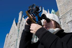
 Who needs GPS? Elizabeth Carbone '12 calculates her latitude at Avery Point, Conn., with the help of a sextant. |
Think of the proverbial “billions and billions” of stars in the universe and the hundreds or thousands we can see from Earth. Now consider that, for centuries before the advent of computers or GPS navigation, experienced sailors used only 57 of those stars, plus the sun and moon, to determine their own locations in the vastness of the sea. That’s what 12 students learned to do this year in Henry Parker Hirschel’s Interterm course, “Celestial Navigation.”
Hirschel is an instructor captain for the Steamship Authority in Woods Hole, Mass., and is known to almost everyone as Captain Henry. This was his third year teaching the Interterm course. The students spent class time, some of it up on Merrill Beach, learning how to “shoot the sun”— how to measure the sun’s angle in the sky using sextants. (“If anyone drops this sextant,” Captain Henry warned them, holding up the most expensive and finely crafted one, “they get sent to Williams College for the rest of the year.”) They also practiced using their measurements, the relevant tables in the Nautical Almanac and the necessary arithmetic to figure out their latitude.
On Jan. 21, the whole group loaded into a van, with Captain Henry and a student navigator at the helm, and drove to Avery Point in Groton, Conn., where, looking out over New London Harbor, they did a “noon sight”—a calculation of latitude based on measurement of the sun’s angle at Local Apparent Noon (the few minutes during which the sun is at its highest point in the sky over a particular location).
The next task, a “p.m. sun sight,” was trickier: The students took multiple sextant readings as the sun made its way across the sky, used these readings to draw precise lines on a Mercator plotting sheet and finally determined their location based on where the lines intersected.
Captain Henry was pleased with the accuracy of the students’ reckoning of longitude and latitude—they weren’t far off from what he rather intimidatingly called “truth.” “I think you’re all to academy standards, as far as I can see,” he said. The next day, at the culmination of the course, the class went out to Block Island, R.I., on an actual boat.
Photo by Samuel Masinter '04